Article Search
Search CriteriaArticle Search:
Articles meeting the search criteria
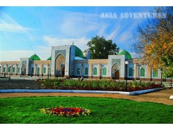
Religious – memorial complex of Imam Al-Bukhari is located in kishlak Khartang of Payaryk district of Samarkand area in Uzbekistan in 15 km from Samarkand city. The complex was built in 1998 on ancient kubba (burial place) of famous Islamic religious figure Imam Abu Abdullakh Mukhammad ibn Ismail Al-Bukhari on the occasion of 1225-years from the date of his birth. The best national masters of Samarkand, Tashkent, Bukhara, Khiva, Shakhrisabz, Andijan, Kokand and Namangan took part in its building, which had been finished by October in 1998. As a result, a new complex took in the best traditio..

The Kyzylkum desert (Turkic ‘red sand’) is one of the most extensive deserts in Asia. The desert is situated between the Amudarya and Syrdarya rivers. Most of the Kyzylkum desert lies in the territory of Uzbekistan, with only a small portion of it extending to the territory of Kazakhstan. The Kyzylkum desert occupies an area of 300 thousand sq km and is bordered by the Syrdarya river from the northeast, by the Amudarya from the southwest, by the spurs of the Tien Shan and Pamir-Alay mountain ranges (Nurata Range) from the east, and by the Aral Sea and the Aralkum desert, a desert that has fo..

There are more than two thousands lakes on the territory of Tajikistan and the Sarezskoe Lake is one of the most beautiful lakes. It is situated in the middle of the high mountains land Pamir. It was formed in winter 1911, when due to an earthquake the valley of the Bartang (Murgab) river – the main confluent of the Amudarya River, has been obstructed by mass of stones that slept down and created a dam. The Usoy village with the whole population has been totally buried under the rock debris. The landslide is approximately 2 km3, its maximal height is 500-700 m more than initial bottom of the..

Engels Peak 6510 m, (firstly it called Tsaritsa Peak) is a mountain summit in Shakhdaryinskiy Range on South-West Pamir, Tajikistan.
Firstly the ascension on Engels Peak 6510 m was accomplished by Georgian climbers in 1954 along the route from the shute of south wall (5A) under the direction Kuzmin K. And already in 1963 the team of army expedition under the direction of Nekrasov V. passed the most difficult route for that time along south-east rib, and next years more difficult routes were made. Lately there wasn’t any climbing season without the facts that one or several sport expedit..

This is mountain summit in south-western Pamir, in western part of Shakhdaryinskiy Range, Tajikistan. It’s a highest point of Ishkashim Range. There are some glaciers on the slopes. There are steep rocky walls from the north side. The first ascension to Mayakovskiy Peak was accomplished in 1947 by Soviet climbers under the direction of Budanov V.A.
In 1946 the treiangulation of the region was carried out by military topographers. The enough sensation results after all were taken after data processing. There were just approximate estimation of summits altitudes, and it was supposed that the ..

Karl Marks Peak (first is called Tsar Peacemaker Peak) is the highest point of Shakhdaryinskiy Range in south-west Pamir, Tajikistan.
The first climbing expedition to Karl Marks Peak was in 1946 under the direction of Beletskiy E. The scouting of Rushanskiy Range was hold in the region of Patkhor Peak.
Successfully finished the first part of the expedition, in the second part of August the expedition caravan crossed via Shugnanskiy Range via Duzakh-dara Pass, and came to K.Marks Peak along the valley of Redjig River. Two scouting groups went to the peak foot along the valleys of Sh..

Khodja-Mumin salt group, one of the most unusual and interesting creation of nature is located in the South Tajikistan not far from Kulyab city. The huge salt mountain in the shape of dome towers above environing plain for 900 m (the altitude is 1332 m.a.s.l.). Khodja-Mumin is seen at a distance of tens kilometers. Because of the salt whiteness it seems that the mountain is covered by fresh snow. On the plan the dome has an oval shape and it’s length is as far as 8,5 km.
Khodja-Mumin and nearby Khodja-Sarkis massif are the second in the world as regards their capacity after K..
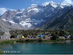
Doubtless, lakes are the principal treasure of the Fan Mountains. There are more than 30 of them there – large and small, deep and shallow, legendary and lost in inaccessible gorges. It would hardly be possible to find many places in the world with such a dense concentration of beautiful many-coloured lakes – their colour ranging from tender green to dark purple – in a rather small area covered with majestic snow-capped mountains and overlooked by a serene blue sky.
A complex intersection of mountain ridges and the activity of glaciers had created conditions favourable for the forma..

Fedchenko glacier is the largest in the former USSR and one of the biggest in the world. It is 77 km long and from 1700 to 3100m wide. It springs from the foot of the Revolucii Peak at north mountainside of the Yazgulemskiy mountain range and runs along east mountainside of the Science Academy mountain range. Ice in the middle of the glacier is approximately 1000m thick, the glacier’s rate of movement is about 66,8 centimeters/24hours, total glaciation’s area is 992sq.km. The glacier is largest middle-latitude valley-type glacier in the world. The glacier’s upper end is at an altitude of 628..
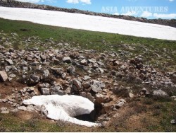
The Polatkhan cave is hidden on the plateau of the same name in Gazalkent district of Tashkent province in the mountains of South-West Tien-Shan. It was discovered by the speleologists from Novosibirsk in 1988. The following year the cave was passed through to the depth of more than 400 meters. Later in the course of the joint Tashkent and Novosibirsk expedition, speleologists reached a depth of 508 meters.
The cave consists of a vertical shaft with wells up to 80 m deep.
..
One more big cave, Kievskaya, is situated in the Urgutskij district of Samarkand region near Kamangaran village on Kirktau mountain range (part of Zarafshan mountain range). This cave was discovered in 1994 by speleologists from Kiev. As the result of 3-year investigations the maximum depth of 990 meters was reached. The cave consists of a vertical shaft and more than 30 layers joined by shafts with depths from 10 to 90 m located one over another. The cave ends with a lake of almost 10m depth. Attempts to dive with an aqualung lower than that mark failed: it was impossible to dive down throu..

The Hissar Cave is situated on the karst plateau Kyzyl-Shavar on the Hissar Range (Yakkabag District, Kashkadarya province, Uzbekistan) at an elevation of 3,530 m above sea level.
The Hissar Cave was discovered in the course of a joint expedition organised by the Ternopol and Kiev speleological clubs in 1981 and received the code T21. The cave can be entered through a little hole in the thalweg of a seasonal brook in the central part of the plateau. The cave begins with a cascade of ice-clad vertical shafts continuing to a depth of 60 m, which then pass into a system of sloping meander..

The Nurata National Reserve is situated in the central part of the Nuratau Range. The reserve’s area is 17,752 ha. The Nurata Reserve was established in 1975 with the purpose of conserving the population of a rare endemic subspecies of Severtsov’s urial (Ovis ammon severtzovi) included in the Red Book of IUCN and the Red Book of Uzbekistan. The other goal of the reserve is to preserve the genetic variety of the walnut and other cultivated types of fruit, as the territory of the Nurata Reserve was acknowledged as one of the centres of plant cultivation in Central Asia.
The Nuratau Ran..

The Zeravshan National Reserve is situated in the southeastern part of Samarkand province, in Jambay and Bulungur districts. The reserve begins from the Pervomayskaya dam near the border with Tajikistan and stretches along the right bank of the Zeravshan River to the Chapan-Ata hills 8 km from Samarkand.
The Zeravshan National Reserve was established in 1975 with the purpose of conservation of riparian forests in the Zeravshan Valley. The reserve has the form of a narrow strip, from 300 to 1,500 km wide, stretching 47 km along the right bank of the river, with a total area of 2,352 ..

Chalpyk fortress (Chilpyk, Chil’pyk, Shilpyk), from Turkic – the Tower of Silence, is located in 43 kilometers to the South of Nukus, near the highway to Turtkul. The fortress is visible well from the road.
Chil’pyk is a building with high cob walls, located on the separate natural 35-meters conical hill. Walls of the fortress form an unequal round, 65 meters in diameter with the entrance from the north-western side. Before there was a 20 meters stair well with 72 steps, which led to the entrance on the steepest side of the hill. There is a passage in the foundation, which leads down..

Zarkent Cave is located in the side of small river approximately 7 kms far from Zarkent settlement in Tashkent region.
The cave was founded by geologists (a chief of the party was Lyutikov S.) in 1988 during the process of searching of onyx fields. Vertical entering well didn’t allow descending into the cave to the geologists and after addressing Tashkent speleo section, the cave was gone through till the obstruction on the bottom (mark is -102 m).
The cave consists of 2 entrances. One of them by vertical 18-metered well is lead into the big hall, from this 12-metered bench is lea..

Janbas-kala fortress (from Turkic – sloping fortress) is located in Elikkalin district of Karakalpakstan in 4 kilometers from Kukcha settlement.
Janbas-kala is a frontier fortress in the south-eastern border of ancient Khoresm, located on the way to Turtkul. It is a showy and fascinating ruins on the slope, with a view to old horn of Amudarya. The fortress has a rectangular shape of 200 to 170 meters and it is quite accurately oriented to corners of the earth. As many other fortresses, Janbas-kala dates back to the early ancient period. It was founded in the IV century BC and was used..

Dishan-Kala “Outside” fortress of Khiva. In the middle of XIX century the city was surrounded by almost six kilometers fortified wall made from mudbricks. A height of walls was about eight meters and thickness in the bottom was about six meters. Ten gates led to the city. Unfortunately, only three gates Kosh-darvaza and Khazarasp-darvaza and fragments of fortified wall are remained to the present day. Few landmarks: Nurulla-Bay’s palace (1912), are remained here. The palace was built by Mukhammad-Rakhim-khan II for his son – future khan Asfendiyar. Except local people, Russian and German mas..

The country palace of Sitorai Mohi-Khosa is situated 4 km north of Bukhara. The name of the palace can be translated as ‘palace similar to the stars and the moon’. The palace was a summer residence of the emirs (rulers of Bukhara). Its construction started in the late 19th century, when Emir Ahudkhan ordered to send the best masters of Bukhara to Russia (St Petersburg and Yalta) for adopting the methods used by Russian architects. The palace’s main entrance is decorated with mosaics of diverse colours and shades, which is not characteristic of Bukhara where various tinges of blue and green w..

The Hissar National Reserve is situated in Kashkadarya province, Uzbekistan, on the western slopes of the Hissar Range, at an altitude ranging from 1,750 m to 4,349 m above sea level. From the east and southeast the reserve is bordered by Surkhandarya province, Uzbekistan, the borderline running along the ridge of the Hissar Range, from the north – by Tajikistan. The Hissar Reserve was established in 1983 through joining two independent mountain reserves – the Kyzylsuy Reserve and Miraki Reserve. As the territories of the two reserves were quite significant in area, the present-day Hissar Re..

Toprak-kala fortress is located in Ellikkalin district of the Republic of Karkalpakstan in 12 kilometers from Buston settlement (27 kilometers from Biruni city) and it is the most magnificent and valuable among other fortresses of ancient Khoresm. In 1938 a famous Soviet archaeologist S.P.Tolstov, during execution prospecting works in 50 kilometers from the right bank of Amudarya, discovered the ruins of ancient city with area of 17 hectares, walled 20 meters height and 12 meters thickness. So Toprak-kala or Earth city was opened, which was the capital of dynasty, ruled in Khoresm in II-III ..

Dzhanpik fortress (Jampyk) – kala is located only in 6 km from the highway Urgench-Nukus (50 km from Nukus) on south-western branch of Sultan-Uizdak ridge not far from banks of Amudarya river, on the border of Baday-Tugay reserve.
An outstanding Soviet archaeologist S.P.Tolstov, who was the head of Khoresm archaeological and ethnographic expedition in Karakalpakstan, called Dzhanpik-kala the most beautiful fortress in Khoresm. Dzhanpik–kala is specially showy in the evening from the South-East, when the way, running through the forest for a long time, suddenly comes to the mountains. A..

A legendary cave Hazrat-Daud is one of the most popular places of interest in Samarkand region. A legend tells that bible Tsar David (Daud) escaped from his enemies through this cave, moving apart the rocks with his hands.
Hazrat-Daud patronizes smiths (according to the legend he shaped the iron with bare hands). Thousands of pilgrims come here to touch the hand prints of Hodja-Daud on the walls of the cave, asking for health and wishes to come true.
The cave is situated in the Mirankul Mountains in 40 km from Samarkand. In the beginning of the mountain area, in a large garden are many p..

Nurata today is just a small 40,000 population big town, administrative centre of the district. But it had seen days of glorious past of which remind ruins of the old-time fortress beetling at the mountain spear over the holy spring steadily producing 230 litres of fresh clear water. The spring, undoubtedly, was a reason why people once settled there. Around the spring, an architectural complex has developed to include earliest in the Central Asia multi-dome Chil Sutun mosque (9th c AD), Panch Vakta mosque (16th c AD), grave of Abu Hassan Nuri Baghdadi (the Arab sheikh who preached Islam the..

 Centralasia Adventures
+998712544100


