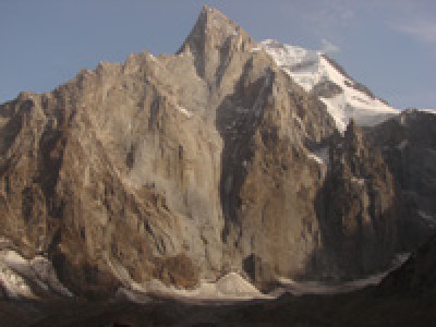
Aksu is located in the Turkestan ridge (Pamir-Alai), on the west side of Matcha mountain knot, and is located about 120 km to the south of Khujand city. Administratively Aksu refers to the Aksay district (Batken region, Kyrgyz Republic). The area is characterized by the beauty of untouched nature and unusual rock peaks, whose height often exceeds 5000 meters, such as Aksu (5355m), Block (5239m), Iskander (5120m) and many others. These mountains are made of dense granite, and the walls have a height difference of up to 1500 m. Rarely visited beautiful gorges, peaks and passes of the region create perfect conditions for climbing and trekking. Mountains, but rather called- rock towers, formed tens of millennia ago by the movements of the earth's crust, have walls of up to 1.5 km.
First expedition of this mountain area was held only in 1982, when during the flight by helicopter for the purpose of analyzing glaciers and snow cover it was decided to study the highest peaks of the Turkestan range
at the close distance. While flying above the Valley of Laylak River, climbers were amazed by the verticality of the northern wall of the severe triangle of Aksu, which is higher than the other five-thousandths of this region. Thanks to these conditions, in the next year- 1983, Aksu region was chosen as the place to hold the championship of the USSR in mountaineering, which led to the increase in interest from the point of view of wall ascents to this area.
The highest point of the region is Pyramidal peak 5509 m. From 1982, climbers make the ascents of highest category of complexity in this region. The tops of the mountain group Aksu create a rocky barrier, which covers the Aksu Glacier: Iskander 5120 m, Petrograd 5165 m, Admiraltez 5090 m, Aksu 5355 m, A. Bloka 5229 m, Aktyubek 5125 m, Dostoevsky 4974 m. are located from west to east of the area. From the base camp site ~ 3000 m, the approach to the upper reaches of the Aksu glacier takes about 2-3 hours. In the neighboring (to the west) Karasu gorge, there are peaks, 5011 m, 50 years of Moscow Spartak 4690 m, the northern spur from the peak of Vizbor 4655 m to the peak of the Dalniy 4457 m. Far to the west in the Uryam gorge, there is Sobakh peak 5300 m and the Parus peak.
Climate
In the summer the weather in this area is warm with a low frequency of rainfall. The basic daily climate in this area is clear cloudless weather before lunch and after lunch there is cloudiness, concentrating over the main, high part of the ridge. By evening, precipitation may fall in the form of rain or snow.
Routes mostly lay through rocks and walls and require climbers a high level of preparation. The length of the walls is up to 1000 m- 1500 m. The rocks are strongly smoothed, composed of metamorphosed granites of large-block type with a small number of cracks for hooks. Routes mostly pass through cracks, which are often packed with ice. For passage, the entire arsenal of available technical supplies is used: various types of rock and ice hooks, mortgage elements, screw pitons, sky-hooks, etriers and others. The speed of the vertical movement often does not exceed 80 -100 m per day. Still there are peaks of considerable height, composed of shale, and therefore destroyed, thus considered potentially dangerous. As an example; the highest point of the Turkestan range - Peak Pyramidal (5509 m).
Aksu Tops.
Here you can climb to the tops of Aksu (5355m), Northern Aksu (5217m) A. Blok (5239m), Iskander (5120m), Petrogradets (5165 m), Admiralteus (5090 m), Aktyubek (5125 m).

 Centralasia Adventures
+998712544100


 Posted by

